The drive to Baie Saint Paul from Ste Anne de Beaupre was short but eventful...the constant up and down of highway 138 tested the engine on our fully loaded up Hyundai Elantra...I was downshifting A LOT on the climbs. However, the drive down into Baie St. Paul was a stunning plummet into a valley.
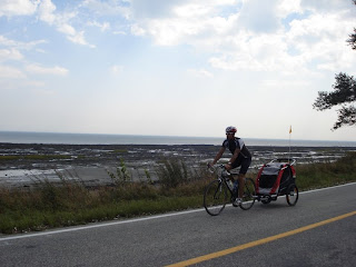
So on to the biking. One day we did a little tour of an island called Ile aux Coudres (hazelnut island). On the drive to the ferry, we decended a hill that started out at 10%, and then bottomed out at 18%! This was one of many times on our trip where it felt as though the road we were on was going to plummet into the St. Lawrence. After a quick ferry ride to the island, we put together our bike trailer, loaded up Lil’ D and started riding into a vicious headwind. The roads were relatively flat…and the loop was only 23km. Overall it was a very leisurely ride, which unfortunately was lacking any real points of interest, or any lookouts for that matter. The view across the St. Lawrence to the North Shore however was quite impressive, despite being a hazy and humid day. An interesting thing to note...475 years ago, Jacques Cartier landed on Ile aux Coudres...now there's some history!
This hill starts at 18% then "mellows out" at 10% before reaching the top. (Sorry about the poor picture quality....it was hazy and the shore was pretty far away.)
Cruising around Ile aux Coudres.
Leaving the island, we were parked on this 10% grade while waiting for the ferry. Hills were a recurring theme in the Charlevoix area, and I was blown away by the sheer size of them...to be honest, they're not just hills in this area, but mountains. This a beautiful part of the country, no doubt.
On our last day in Baie St. Paul, I got out for a short ride, that involved a 5km climb out of the town. The average grade of the climb was 10%, and it took me 17 minutes to crest. After it flattened out, I continued on, and when I had reached 25 minutes since the start of the climb, I had already ascended 400 metres! Coming back down the climb, the last 2km provided some amazing views into the valley that comprises Baie St. Paul.
The signs don't lie.
The road just before it plummeted down.
I stopped at a lookout to snap some pics...this is the bay that obviously gives Baie St. Paul its name.
This sign was in Ste. Anne de Beaupre. Unfortunately, this had nothing to do with cycling, or a cyclorama for that matter (whatever a cyclorama might be!). Turns out the building next to this sign houses a 360 degree mural depicting scenes from Jerusalem. Needless to say, I was quite disappointed.


No comments:
Post a Comment